
Hiking the Border Route Trail in the BWCA
The Boundary Waters is known for its canoeing and very few people take advantage of the awesome hiking opportunities that exist. The Gunflint Trail has endless hiking trails of all lengths including the Border Route Hiking Trail and all of it’s spur trails.
Last week I was able to get out and camp on Rose Lake. We chose a campsite that the Border Route Trail passes right through. It seems a little bit awkward to have a trail go right through your camp but in the four days we were there no one passed through. I love to hike so one day I hiked to the east and the next to the west.
The Border Route Trail begins at Magnetic Rock about 45 miles from Grand Marais and stretches all of the way to Lake Superior. There are a number of spur trails that I have hiked and I had been on both sections of the trail that I hiked but every time you hike a trail you see something new or find something else to appreciate.
Going to the east I quickly came upon the long canoe portage into Rove Lake. It was lowland that followed a creek and passed by many beaver ponds. Beaver activity was obvious everywhere with paths in the woods and chewed off stumps. The plants that grow around a swamp and wetlands are so interesting to look at and I really enjoy a particular scent that it gives off. I’m not sure what plant produces the smell but it reminds me of something similar to Patchouli.
After the portage trail ends the hiking trail heads into the woods and away from the lake. The trail isn’t like one you’ll find in a State Park as there are dead falls, rocks to scurry over and mud holes to slug through. I hiked a little over four miles to the intersection of where a trail leads down to the Clearwater Lake hiking campsite. The bummer about hiking from a campsite is that you travel the same path in as you do out, but as I’ve said before, you notice new things and a hike through the woods is always enjoyable.
Stairway Portage and the waterfalls were the destination for the second day of hiking. Josh decided he would hike there with me while Abby and Mike canoed and fished their way there. Josh actually took off like a gazelle immediately and I didn’t see him until I made it to the falls. His long legs, sure footing and athleticism was too much for his mother to keep up.
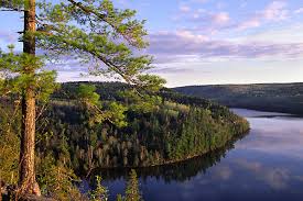
This part of the trail has more elevation change as it goes up to the bluffs overlooking Rose Lake. It’s spectacular scenery and there are places you can see back into Duncan Lake, Arrow Lake in Canada and even Rat and South Lake. Then there are parts of the trail that make you feel like you are in a jungle because there are so many Thimbleberry leaves covering the path and raspberry bushes scratching at your legs. It’s a little over 3 miles to get to Stairway Portage and when Mike and Abby got there, after catching a nice lake trout, we cooled off beneath the falls. This is a popular day trip spot and I’ll talk more about it in a different blog because this one is getting long enough.
After cooling off I turned back to hike home to the campsite while Josh fished and paddled with Mike and Abby. While this campsite was ideal for hiking any of the sites on Rose would be good if you don’t mind paddling to the Stairway Portage or the portage at the end of Rose. If you paddled there then you would avoid hiking through the campsite and you really don’t miss much of the trail at all. I could have hiked the Daniels Lake Spur Trail as another trip or the Caribou Rock Trail or even another section of the Border Route Trail along Rose that heads toward South Lake. Like I said, the opportunities are plentiful when it comes to hiking the BWCA especially when your camped on one of the lakes the Border Route Trail passes by.
The Border Route Trail is maintained by volunteers. You can help clear the trail, donate money or find out more information about the trail on their website. The photo below was taken from the web, my photos are still on my camera.
Leave a Reply
You must be logged in to post a comment.