
Boundary Waters entry points opening up
The recent rains, cooler temperatures and additional fire resources in the Superior National Forest are allowing the USFS to open up most of the Boundary Waters Canoe Area entry points on September 4th. Unfortunately the lack of containment of the John Ek Fire is prompting officials to keep the end of the Gunflint Trail entry points closed. We were hoping to have Saganaga and Seagull Lake open back up for at least day use but that didn’t happen. We are hopeful firefighters will get some work done quickly around John Ek and Mother Nature will bless us with more rain in the near future so folks can paddle and camp on Saganaga once again. We’re thankful other BWCA entry points are open and Voyageur Canoe Outfitters outfits to all entry points on the Gunflint Trail so give us a call for your September canoe camping trip in the BWCA. 218-388-2224
Forest Service News Release
Media contact: Joanna Gilkeson
(218) 349-5137
Superior National Forest reopens portions of the Boundary Waters Canoe Area Wilderness and National Forest lands
Closures remain in place for the Greenwood, John Ek and Whelp fires
Duluth, Minn., September 1, 2021 — The Superior National Forest is reopening some areas of the Forest, including the Boundary Waters Canoe Area Wilderness, given recent rains, cooling temperatures and progress made on active fire. However, certain closures will remain in place where active fires remain on the landscape.
The Forest is lifting the full closure of the BWCAW, the Crooked Lake closure near the fires in Canada. The Forest is slightly modifying closure maps for the Greenwood Fire, and the John Ek and Whelp Fires. The closure of Forest Service land at the Upper Gunflint Trail remains in place.
“We’re thrilled to reopen some of our public lands to visitors. The drought is not over but we’re starting to see more rain and lower temperatures. These conditions moderate fire activity and lessen the chance of new fires showing up,” said Connie Cummins, supervisor for the Superior National Forest.
“After talking with our fire experts about the latest data and weather conditions, we believe we have the capacity to manage the potential risk to the public of wildfire in some portions of the Forest,” Cummins added.
What this announcement means for visitors:
-
- Full BWCAW Closure is being lifted: Portions of the BWCAW will reopen, effective September 4, including the Crooked Lake area near Canada.
- If you had a previously reserved permit for after September 4, your permit is still valid.
- Available quota permits will be live for reservation on Thursday, September 2 at 12:00 PM on Recreation.gov.
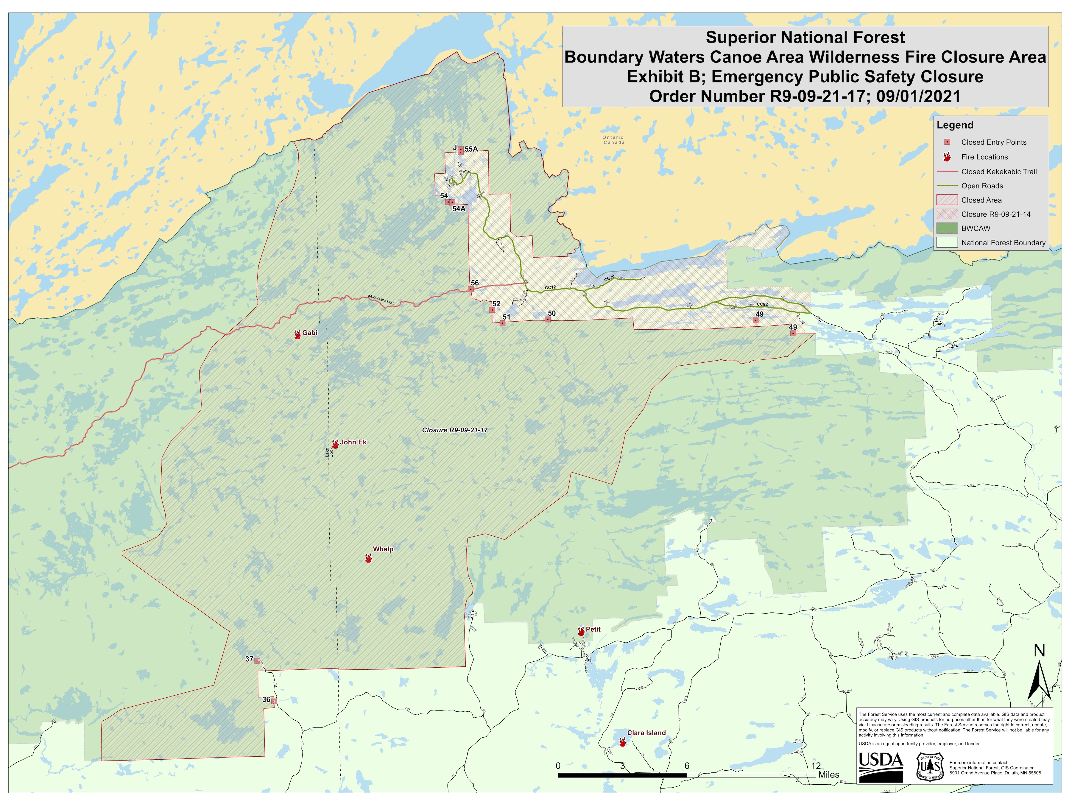
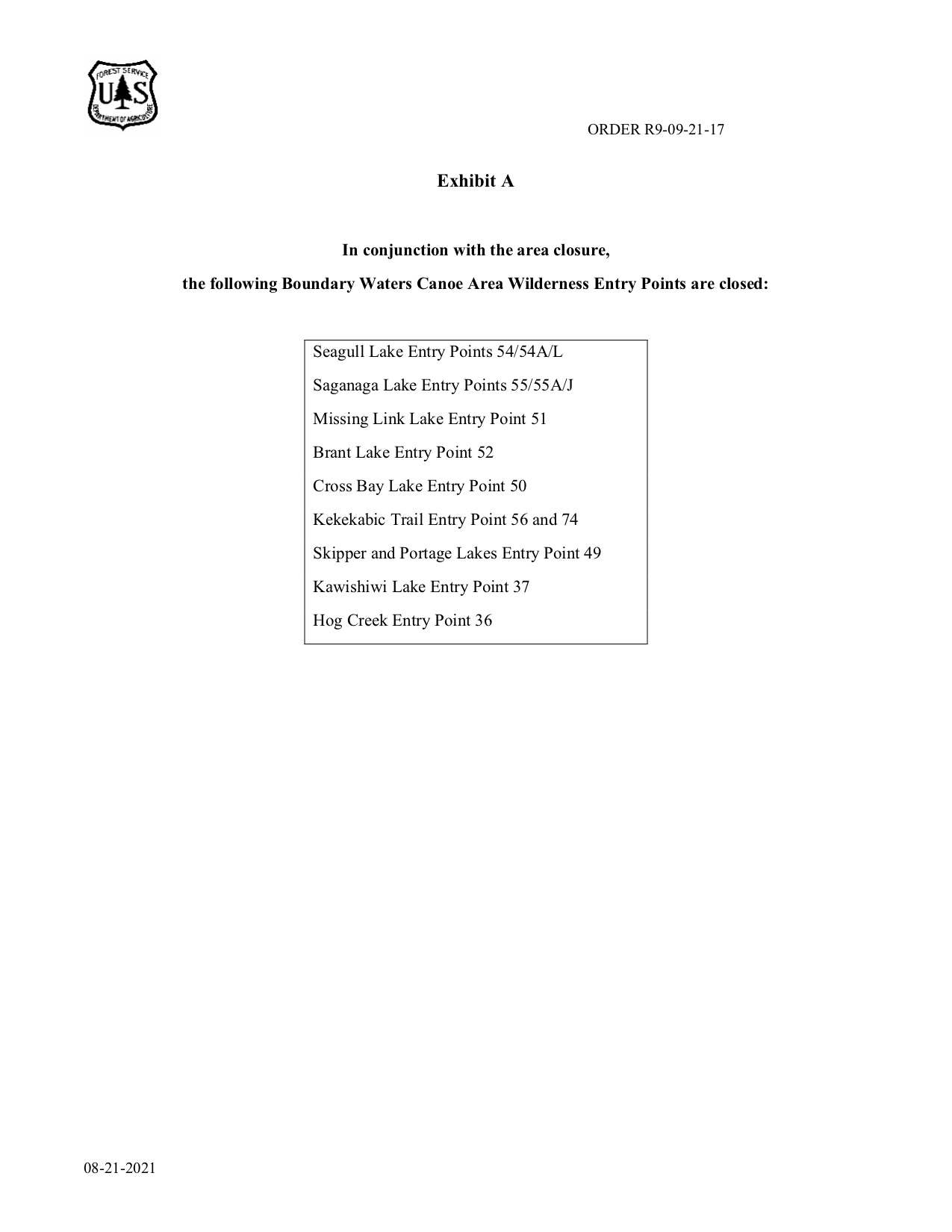
- BWCAW Closure due to John Ek & Whelp fires: A new closure area has been drawn for the John Ek and Whelp Fires: Seagull Lake EP #54/#54A/L, Saganaga Lake EP #55/#55A/J, Missing Link Lake EP #51, Brant Lake EP #52, Cross Bay Lake EP #50, Kekakbic Trail EP #56, Skipper and Portage Lakes EP #49, Kawishiwi Lake EP #37, Hog Creek EP #36.
- Full BWCAW Closure is being lifted: Portions of the BWCAW will reopen, effective September 4, including the Crooked Lake area near Canada.
Leave a Reply
You must be logged in to post a comment.